Pima County issued the following announcement on Aug. 9.
An area rich with history and biodiversity soon could become a hotspot for outdoor enthusiasts following a recent partnership among Pima County, the Regional Flood Control District and the Town of Marana on infrastructure upgrades at two amenities along the northern edge of the Tucson Mountains. Pedestrian-only trail improvements and new signage at the County-owned Los Morteros Conservation Area and ongoing work on the Town of Marana's El Rio Preserve will make both more accessible and more beneficial for County residents and visitors alike.
The two sites sit across Coachline Boulevard from each other, just east of Silverbell Road, in the shadow of Rillito Peak – an oft-settled and oft-travelled stretch for more than a millennium, but both sites are connected by a shared history of human settlement. Once home to ancestral Native American villagers, this area was used as a campsite during the Spanish Colonial period by the 1775 Juan Bautista de Anza expedition and later by Mexican and Territorial American period ranchers and farmers, including the Pascua Yaqui. The 1858 Butterfield Point of the Mountain stagecoach station also once stood here. This significant history is a major reason Pima County acquired the core area of the site, known as Los Morteros, using 1997 voter-approved bond funds, with additional bond money in 2004 going to support preservation and management of the 120 acres.
Los Morteros translates to “the mortars,” for the many carved holes created by peoples ancestral to the Tohono O’odham. The large bedrock boulders found on the landscape were once used to grind and mill mesquite beans and other crops.
“Los Morteros is one of two County-owned archeological conservation areas that are open to the public with trails and interpretive signage,” Office of Sustainability and Conservation Archaeologist Cannon Daughtrey said. “Acquiring a portion of this site was a boon for Pima County and the public, considering the loss of so much open space, biological habitat and cultural heritage in the face of development. Increasing interpretive signage for the public to learn about the importance of this place is a goal that has now been fulfilled. Project collaborations represent valued opportunities. Los Morteros is an area that should be respected for the stories it holds and gratefully, it will continue to be preserved for the benefit of the public and future generations.”
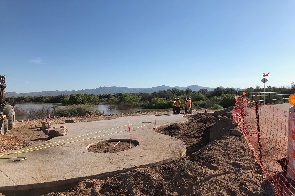
The fragility and cultural significance of Los Morteros coupled with numerous land-use regulations, deemed any improvements to the site should all be passive. Improvements included erosion control, pedestrian trails and the placement of interpretive signs and a northern entry point. A licensed Professional Engineer, Flood Control Civil Engineering Manager Deirdre Brosnihan welcomed the challenge.
"Normally, installing a decomposed granite [DG] trail requires roughing up the existing ground surface, but to avoid disturbing any irreplaceable items, we spread DG on the existing grades, following existing trails. Instead of sinking the interpretive signs posts into the soil as our design typically calls for, we came up with a new design of mounting them to a concrete slab,” Brosnihan said. “The path is raised, the signs are raised. The only thing we put in the ground were the posts for the new pedestrian gate at Coachline.” The improvements at Los Morteros were constructed by Hunter Contracting Company and monitored by Desert Archeology throughout construction. Desert Archaeology also contributed content for the new signage denoting important historic events along the trail.
A crosswalk built by Marana Transportation crews on Coachline links Los Morteros to El Rio Preserve – a physical symbol of the County’s and Town’s approach in developing and promoting the recreational and educational opportunities represented by both amenities.
"We couldn’t have asked for a better partner than Pima County,” David Herman, Town of Marana’s Parks Superintendent said. "It really has been a case of synergy, The Town and the County working together to accomplish more than each could alone. It started with a conversation at a Flood Control meeting. And now we have a great area, we think of them as outdoor classrooms, one for wildlife and one for history.”
El Rio Preserve's history begins in the early 1960s when state transportation crews began to dig a "borrow pit" to provide material for construction of Interstate 10, leaving an un-engineered earthen berm as partial protection from flooding. The Town purchased the property in 2003 and it served as the home of a popular disc golf course from 2009 to September 2014, when heavy rains altered the course of the Santa Cruz and overwhelmed the berm, creating what quickly became known as “Lake Marana.”
While it required moving the disc golf course slightly east (slated to open in 2021), the transformation of the site to a riparian area proved to be a windfall for birdwatchers, with some 250 avian species recorded in and around the wetland in recent years, including Canada geese, herons, egrets and sandpipers.
To accommodate this birding boom, Marana leaders created the Preserve area in 2015 and in late July broke ground on a project to add an observation deck scheduled to debut in early October. Other design elements include a plaza with interpretive signage, a sitting area, butterfly garden, native landscaping and water harvesting basins added to the existing ramada and parking areas, built by the County in 2016. County crews this spring paved the formerly gravel lot maintained by the Town, which gives horse trailers and recreational vehicles better access to the Chuck Huckelberry Loop and the Anza National Historic Trail.
A pedestrian path running the length of the southern edge of the El Rio Preserve will anchor a system of trails and footbridges through the 104-acre site planned for the next phase of work. Phase two also includes plans for a new 18-hole course disc golf course along riverbank just to the east of the wetlands.
“The whole 300-acre El Rio Recreation Area really will be another jewel in the region’s crown of outdoor amenities,“ Marana Parks and Recreation Director Jim Conroy said. “From the Preserve to Los Morteros to the existing El Rio pocket park with a playground and basketball hoop, it offers an incredible convergence of recreational and environmental education activities – and the return of a first-class disc golf facility will make this one of the Southern Arizona's most versatile and accessible destinations.”
A pending agreement with the Cortaro-Marana Irrigation District will provide the ponds with a permanent source of non-potable water. That, combined with stormwater run-off and the occasional Monsoon flood, will help circulate and prevent stagnation to keep mosquitoes to a minimum.Marana also plans an active vector control effort.
Safeguarding it all falls to Brosnihan who is overseeing the design and ultimately construction of soil cement bank protection along the northern face of the Preserve. The bank protection is designed to correct and prevent the existing erosion issues the Preserve currently experiences by reducing the frequency and speed of water entering the site. This low flow bank protection will still allow for connectivity between the Santa Cruz River and the Preserve and in large events it will overtop to allow water to enter the Preserve which functions as a floodplain to the Santa Cruz River.
"We tried to find a balance between public recreation, safety and Marana being able to restore the Preserve while accounting for where the river naturally wants to go,” Brosnihan said. “The idea is that the bank protection will protect against more frequent events, more nuisance flooding, but still maintain a connection to the river. This should allow Marana to repair the eastern pond that’s currently in the river’s flow path and provide further restoration and amenities onsite without the fear that it will get washed out each monsoon season.”
To learn more about Los Morteros, check out the Regional Flood Control District's online information page. The Town of Marana maintains a project page for El Rio Preserve.
Original source can be found here.